The geospatial industry is escaping the flatlands by transforming into being three-dimensional. This very subject is the highlight of the Mladen Stojic’s keynote at HxGN LIVE this year.
In early days 3D was mostly about the ‘pretty picture’, and form superceded function. The most common problem was the lack of proper business cases that could support the extra effort needed to create 3D. In a professional work environment, eye candy alone is not enough to justify such a transition.
One of the major goals in collecting geospatial data is to capture change, as accurately as possible. In previous years, much of the local to regional change detection we did was done in 2D, using aerial imagery. It has its fair share of limitations. Things like leaning of structures, influences of shadow and other conditions that affect differences in pixel values all have a negative effect on the ability to detect significant changes.
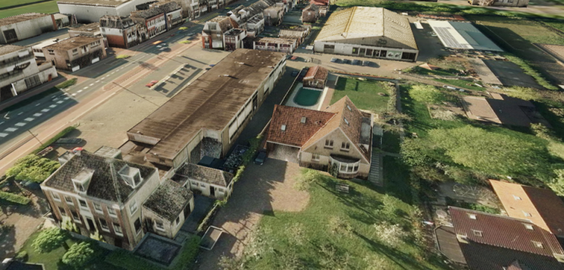
A few years ago, we started using 3D information for change detection, using point clouds that are primarily derived from stereo imagery. This proved to be a great improvement over 2D detection. In essence, an individual pixel value doesn’t matter anymore, as long as the height of the point and its surrounding points matches up. By using the same source, we used for 2D detection, albeit in stereo Hexagon Geospatial technology allows us to automatically create a dense, accurate and up to date point cloud, that shows in great detail what the actual environment looks like and allows for comparison with a previous state.
Furthering the Hexagon Geospatial technology, we have created and implemented a series of spatial models that allow users to custom-search and assess according to their requirements. For example, users can look for building extensions, green spaces, public assets and more. But the buck doesn’t stop there. Going beyond conventional geospatial 3D environments, we construct automated 3D vectors and texture the structures with actual imagery. The result is a full-fledged three-dimensional city (or landscape), providing the basis for uses such as line-of-sight determination, impact analysis for new city developments and more. The defence sector as well can benefit greatly from this solution.
As a reader, you must be wondering if these geospatial 3D models are anything like the ones used for gaming – with fast rendering visuals and stunning looks. Although that is – unfortunately – easily offered in the market today as geospatial 3D models, it is rife with inaccuracies and not entirely suitable for the high-quality results that you desire. Which is why, we at IMAGEM and Hexagon Geospatial alike believe spending more time to focus on accuracy and visuals at the same time should be our primary concern. Plus, with about 90 per cent of processing being automated, creating and using these high-end 3D models doesn’t disrupt your daily work. A win-win situation, wouldn’t you say?
3D is no longer the future, it is happening now and hence must be done right. We must after all ramp up to the possibility of 4D and beyond in the coming years. To know more about our solutions, visit www.imagemnl.com.
Regards,


